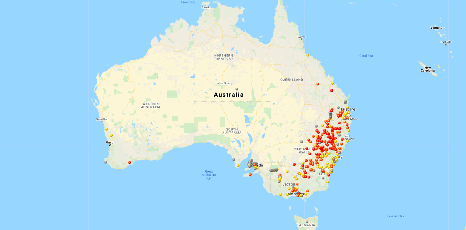
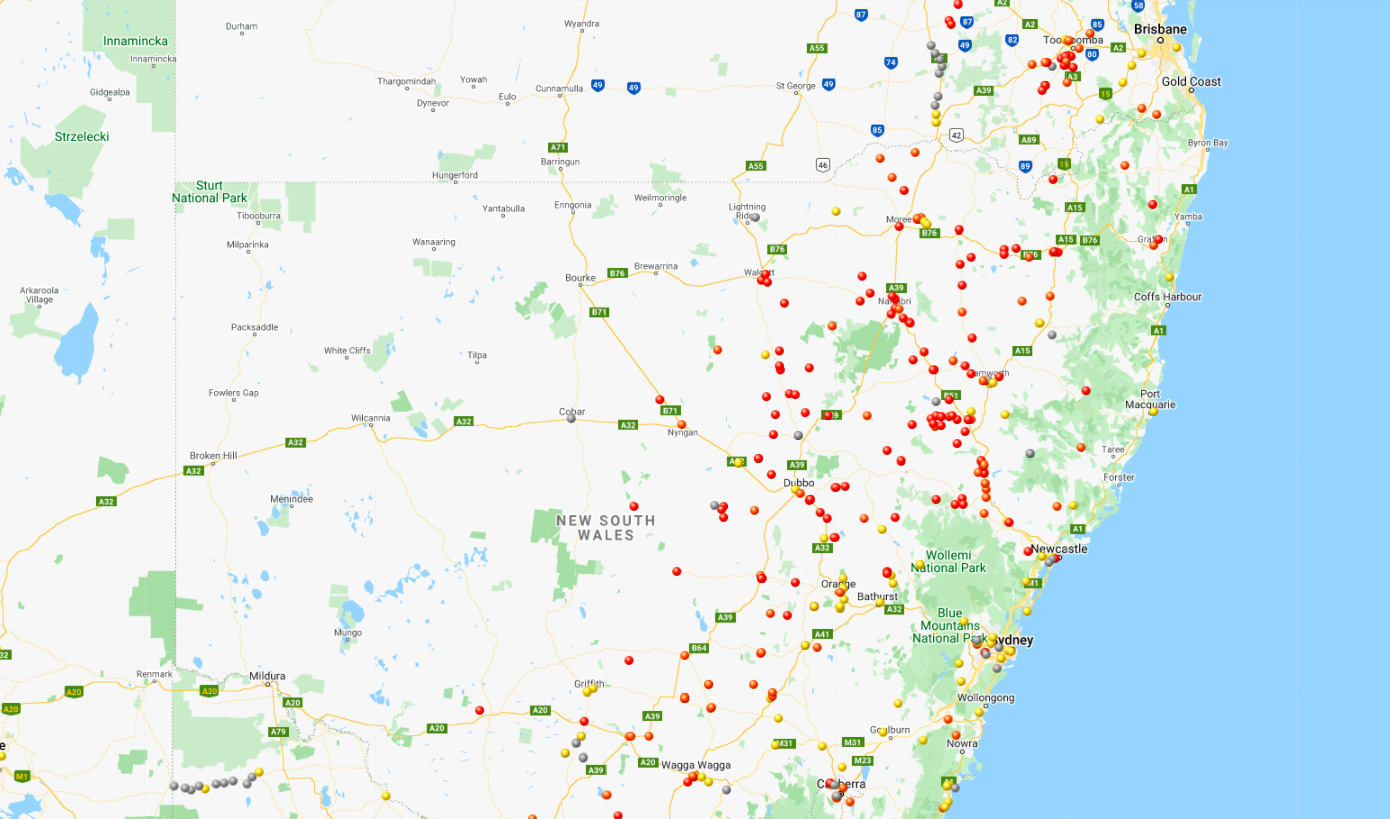
An enormous red and orange blob stretching more than 1000 kilometres from Toowoomba in Queensland to Albury on the New South Wales-Victoria border shows in brutal colour how bad the 2021 mouse plague is.
The worst-hit areas, according to CSIRO's mouse tracker map, powered by the Centre for Invasive Species Solutions, are the Northern Tablelands, Central West and New England regions of NSW.
Red dots, representing the highest levels of infestation, rise in intensity across the Central West, where NSW farmers and residents have been overwhelmed for months.
MORE: You can try out the mouse tracker here [external site]

WATCH: Avalanche of mice filmed tumbling out of NSW farmer's grain bin
Mostly orange dots, reflecting medium mouse activity, begin to appear around Wagga Wagga and parts of the Riverina in NSW, as plague numbers dissipate.
Low numbers of mice, shown in yellow, are being reported in Sydney's west, the Sutherland shire and parts of the South Coast, according to CSIRO.
Toowoomba, which sits in the most severely affected region in Queensland, is surrounded by a cluster of red dots.
READ MORE: Bromadiolone will obliterate mice, but it'll kill eagles, quolls, owls too

READ MORE: Thousands of mice captured in giant water trap on NSW farm
What the peppering of dots fail to show is the catastrophic toll of the mice; devastation of crops and grain stores, people being bitten while they sleep, and homes and furnishings gnawed and shredded by unstoppable waves of mice.
The mouse plague, spurred on by favourable weather conditions and fueled by a bumper harvest season, is causing damage believed headed towards $100 million.
So bad is the plague, health experts are fearful for the mental health of farmers and people who have had to live with the mice for months on end.
How CSIRO tracks the mouse plague
CSIRO relies on farmers and residents and a particular method of reporting to help track the spread of rodents and density of infestation.
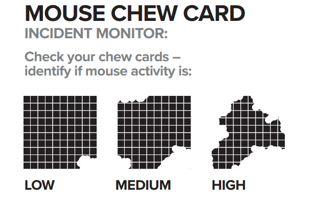
The CSIRO self-reporting system involves farmers pinning down small pieces of paper which have been soaked in canola or linseed oil at intervals in their fields.
The 10 cm x 10 cm card, which is divided into lined grids, similar to a mathematics exercise schoolbook, is then left overnight.
Drawn to the oil-soaked paper, mice will begin to devour and eat the cards.
Farmers check the cards the next day and, depending on how many squares have been chewed away, they can gauge how infested their property is likely to be.
Those results are then uploaded to CSIRO's MouseAlert system and the data is generated into the map.
READ MORE: 'The snakes will follow': Ominous sequel to mouse plague

CSIRO's most recent mouse report in March documented mice numbers as "moderate to high" in many regions of southern Queensland, northern, central and southern NSW, north-western Victoria, parts of South Australia and around Ravensthorpe, WA.
The report said mice have continued to breed through summer and autumn and would reach "a peak at sowing of winter crops".
CSIRO forecast mice would appear in houses and sheds as temperatures drop.
Footage and photos of the mouse plague have created headlines around the world, with recordings of mice "raining" down from inside hay barns and swarms of rodents scuttling through homes and farms.
from 9News https://ift.tt/3oHhfqI
via IFTTT


0 Comments